A rescue is underway after several people tried to drive through floodwater in the Waikato, amid thunderstorm warnings.
Thunderstorms with torrential rain and hail were forecasted for parts of South Waikato, Taupō and Rotorua on Wednesday afternoon.
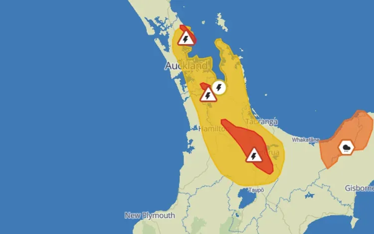
At 1:37pm, MetService detected severe thunderstorms near Tīrau in South Waikato, moving southeast.
A severe thunderstorm warning was also issued for Waikato and Franklin, expected from 3.15pm.
Further north, a severe thunderstorm warning was issued for the Rodney district in North Auckland from 4pm on.
The storms were expected to lie near Omaha, Leigh and Matakana and the outer Hauraki Gulf.
Severe thunderstorm warnings were also issued for South Waikato, Western Bay of Plenty and Rotorua shortly after 4pm.
Emergency services were Waotu Rd, Wiltsdown Rd, and Old Taupo Rd in Waikato on Wednesday afternoon after reports of vehicles becoming stuck because of floodwaters.
Both police and Fire and Emergency New Zealand were called to the area at 3.30pm.
Police closed Old Taupo Rd northwest of Tokoroa and asked people to avoid the area.
The thunderstorms are expected to be accompanied by torrential rain and hail.
That rain and hail could cause surface and flash flooding around streams and urban areas, and make driving conditions dangerous.
People should drive with caution in heavy rain, "if you see flooding, don't drive, walk, swim, or play in the water", Civil Defence Waikato said.
Elsewhere in the North Island, a severe thunderstorm watch is also in effect for areas including Auckland, Coromandel Peninsula, and Bay of Plenty. It applies from 2pm-7.30pm on Wednesday.
"For eastern Auckland, inland parts of Waikato, inland parts of Bay of Plenty west of Te Puke including Rotorua and northern Taupo, there is a moderate risk of severe thunderstorms with localised downpours of 25-40 mm per hour," MetService said.
In the South Island, a severe thunderstorm watch is in effect for Dunedin, Clutha, and Southland. It applies until 7pm on Wednesday.
"For southern Southland, and inland parts of Clutha and Dunedin, there is a moderate risk of severe thunderstorms with localised downpours of 25-40 mm per hour," MetService said.
There is also an orange heavy rain warning in place for Bay of Plenty east of Opotiki, as well as the ranges of Gisborne and Tairawhiti, north of Tokomaru Bay. It's in effect until 5pm on Wednesday.
"We've still got this band of rainfall across the eastern side, and as we head through the afternoon we'll find the return of more showers, some heavy and thundery," meteorologist John Law said.
Down south, a heavy rain watch also applies for the ranges of Westland District near Mt Cook until 9pm on Wednesday.